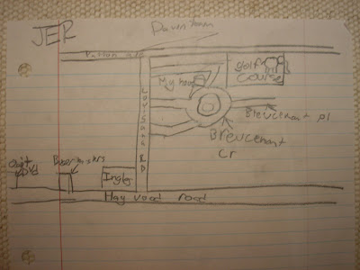
 I was talking with a group of eighth graders at Asheville Middle School. The week before they’d made lists of places they visited in Asheville, and then marked those places on individual Google maps. The maps formed constellations representing their engagements with the city. We talked about them this week. At the end of our conversation I asked them to sketch their own maps of Asheville – the Asheville that wasn’t captured by the digital maps. Here are a couple examples of what they did. The most remarkable feature that I’ve noticed about these (as well as other hand-drawn maps that people have given me of Asheville) is they always include the drawer’s home. It makes sense, I suppose. It’s obvious. The home is the base from which other places flow. But I’ve not asked them to include it. Some do not even indicate streets, not at least in any realistic way. But they always include an indication of where they live. It seems a small but nontrivial point, perhaps basic to people’s mental configuration of space and place.


1 comment:
These are cool, John. And the one labeled "JER" has something called "Golf Course" but it's on the wrong side of the road. But after thinking about it, it's actually the miniature golf course up behind the Patton Avenue fast food row. Of course! It's what a kid would think is more important...
Also, there's a Flickr Group called "Imaginary Coastlines" that are photos of abstract things that in people's mind resembles some kind of coastal map and i wanted to pass that along:
http://www.flickr.com/groups/imaginarycoastlines/pool/
yr pal zen
Post a Comment